Project Summary
This work was developed within the FAO Green Cities Initiative by the Spatial Planning Team at Politecnico di Milano, focusing on the analysis of urban transformation processes through project mapping and spatial interpretation. The project aimed to identify and structure ongoing development initiatives across multiple African cities, in order to support coordination, highlight gaps and overlaps, and enable more targeted and context-specific planning strategies. At the same time, the work addressed a key limitation: most projects are documented programmatically but lack georeferenced data, requiring the development of alternative spatial approaches capable of translating partial and non-spatial information into analytical mapping frameworks
Objectives
Identify and profile ongoing development projects to support urban planning and strategic coordination. Structure heterogeneous datasets to enable cross-city comparison and analysis. Develop mapping approaches capable of supporting spatial interpretation in the absence of precise georeferenced data. Support the identification of potential intervention areas and urban transformation dynamics
Target Groups
Public administrations and local authorities involved in urban planning. International organizations and technical teams supporting urban development strategies. Researchers and practitioners working on spatial analysis and sustainable urban systems
MY ROLE:
Supported the implementation of Green City Action Plans across eight African cities through analytical, organizational, and coordination tasks
Supported programme analysis and contributed to policy-relevant insights for urban development strategies
Developed and managed structured databases on urban development, climate and environmental projects funded by international donors, international Cooperation Agencies, World Bank and African Development Bank
Conducted desk-based reviews of project objectives, funding sources, implementation partners, timelines and geographic scope
Supported reporting and evidence-based decision-making through the preparation of analytical outputs, including spatial analysis, data visualizations, and technical documentation
Contributed to internal coordination by consolidating inputs from different teams and supporting the preparation of reports, presentations and briefing materials for institutional partners
Participated in coordination meetings and workshops and supported follow up actions across multi-stakeholder teams.
The work was developed across eight cities within the FAO Green Cities Initiative: Nairobi and Kisumu (Kenya), Kampala and Hoima (Uganda), Abidjan and Bouaké (Ivory Coast), Pemba and Chimoio (Mozambique).
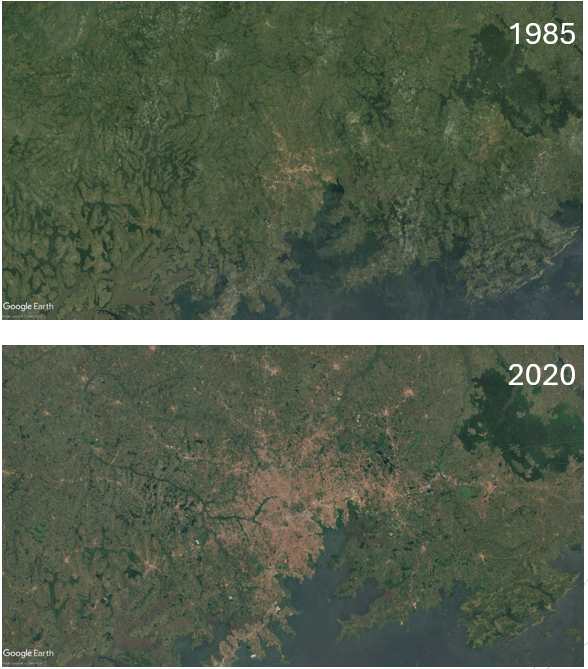
The initial phase focused on the identification and profiling of ongoing urban development projects shaping these contexts. This involved extensive desk research, including the review of planning documents, institutional reports, donor project databases, and publicly available materials. Projects were systematically collected and structured into a dataset including information on sector, implementing actors, timelines, scale, and level of definition. A central aspect of this phase was the attempt to connect projects to specific locations.
However, most available documentation provided detailed programmatic descriptions without any georeferenced information. Projects were often described at the scale of metropolitan areas, corridors, or entire districts, making precise spatial attribution impossible. This limitation led to a shift in approach, from direct mapping of projects to the construction of a spatial framework capable of supporting their interpretation.
However, most available documentation provided detailed programmatic descriptions without any georeferenced information. Projects were often described at the scale of metropolitan areas, corridors, or entire districts, making precise spatial attribution impossible. This limitation led to a shift in approach, from direct mapping of projects to the construction of a spatial framework capable of supporting their interpretation.
In parallel, a second phase focused on data collection and coordination with thematic teams working on different intervention areas, including urban and peri-urban agriculture, forestry, bioenergy, and circular bioeconomy.
Information was gathered through workshop materials, thematic reports, and direct exchanges, in order to identify proposed interventions and areas of interest. Spatial data layers were collected and assembled from multiple sources. Where available, institutional datasets were used, including administrative boundaries, land use maps, and environmental analysis layers. In cases where data was missing or incomplete, additional information was reconstructed through external sources such as OpenStreetMap, ensuring a minimum level of consistency across cities.
Information was gathered through workshop materials, thematic reports, and direct exchanges, in order to identify proposed interventions and areas of interest. Spatial data layers were collected and assembled from multiple sources. Where available, institutional datasets were used, including administrative boundaries, land use maps, and environmental analysis layers. In cases where data was missing or incomplete, additional information was reconstructed through external sources such as OpenStreetMap, ensuring a minimum level of consistency across cities.
The mapping phase consisted in integrating these different layers within a GIS environment, constructing analytical representations that relate environmental conditions, urban structure, and potential intervention areas.
Given the heterogeneity of the contexts, two different mapping approaches were adopted.
For larger metropolitan areas such as Kampala, Nairobi, and Abidjan, characterized by high data density and complexity, the mapping focused on maintaining readability by selecting key layers and avoiding excessive visual overload.
For smaller cities such as Hoima, Kisumu, Bouaké, Pemba, and Chimoio, it was possible to represent broader areas of potential intervention, even in the absence of clearly defined project locations.
In all cases, the maps were conceived as exploratory tools.
They do not represent confirmed or finalized interventions, but rather support the interpretation of spatial relationships between environmental systems, infrastructure, and urban facilities.
They do not represent confirmed or finalized interventions, but rather support the interpretation of spatial relationships between environmental systems, infrastructure, and urban facilities.
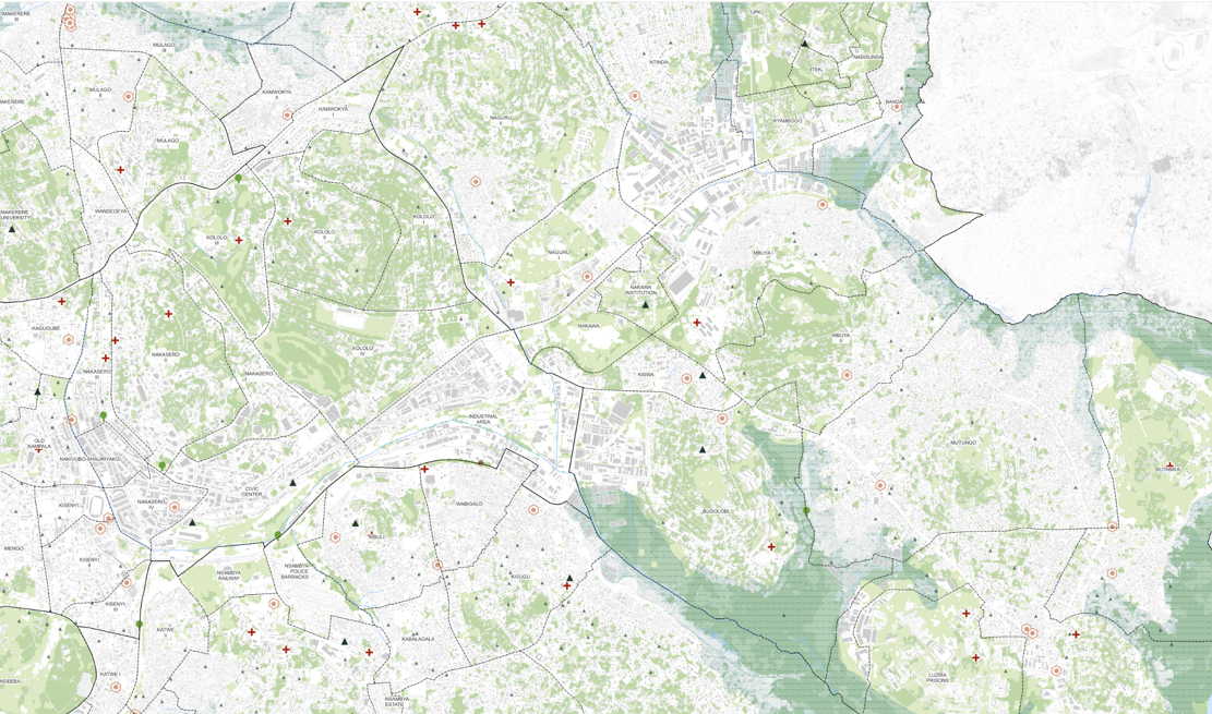
Kampala - Embakasi North
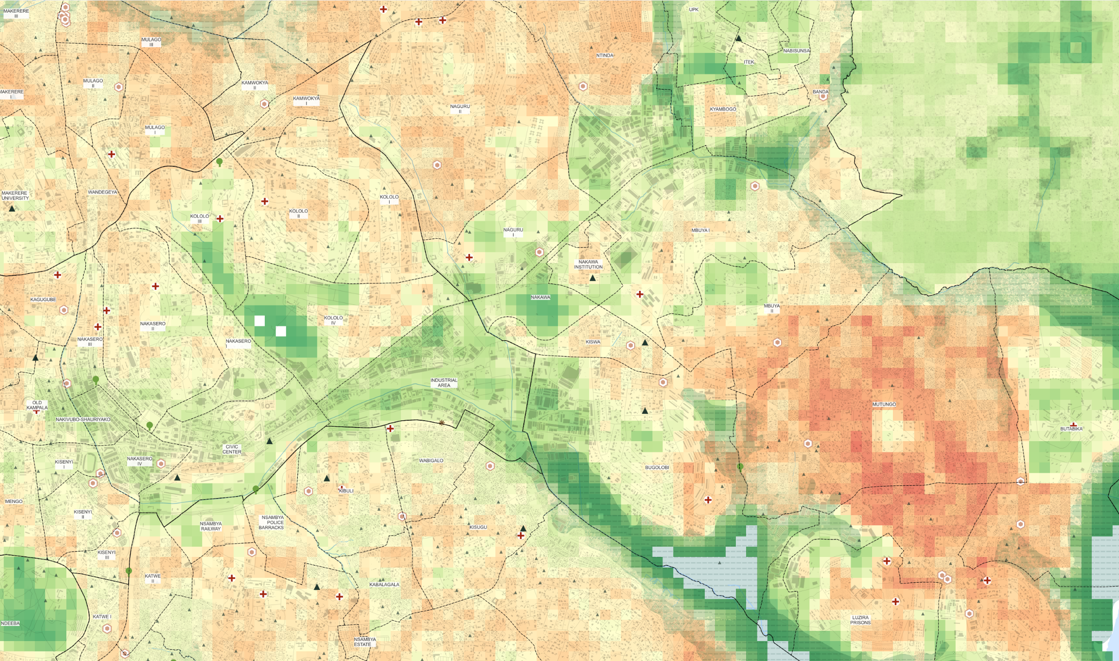
Kampala - Embakasi North | Heat Risk Overlay:
The analysis shows the heat risk for children under 10 years. Yellow to Red areas areas on the map indicate higher heat risk during peak daytime conditions, while greener areas represent lower heat risk.
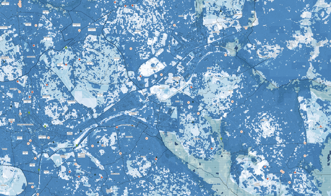
Kampala - Embakasi North | Run-off Retention Capacity
The analysis show the run-off retention capacity in cubic meters, that is the amount of water retained during an extreme rainfall event. The darker area in the map are the one at risk of flooding because they have limited retention capacity due the higher levels of urbanization and sealed surfaces.
A parallel component of the work focused on stakeholder identification and analysis.
Stakeholders involved in urban planning, environmental management, and sectoral interventions were collected from workshop participation lists and thematic reports, and structured into a database. Each actor was categorized according to institutional type and preliminarily assessed in terms of influence and interest, allowing an initial understanding of governance structures and potential coordination dynamics.
Stakeholders involved in urban planning, environmental management, and sectoral interventions were collected from workshop participation lists and thematic reports, and structured into a database. Each actor was categorized according to institutional type and preliminarily assessed in terms of influence and interest, allowing an initial understanding of governance structures and potential coordination dynamics.
Beyond the technical outputs, the work made it possible to identify broader urban transformation patterns across the different contexts.
In cities such as Kampala, the analysis highlights a strong focus on infrastructure provision, transport upgrading, and metropolitan-scale planning, combined with increasing attention to climate resilience and environmental management.
In Hoima, the emerging dynamics are linked to agro-industrial development, energy and extractive sectors, and the progressive consolidation of urban governance structures.
In Hoima, the emerging dynamics are linked to agro-industrial development, energy and extractive sectors, and the progressive consolidation of urban governance structures.